
|
|
During Spring time I was standing on the summit of Binevenagh admiring the stunning view of Lough Foyle and Donegal, I was with Roisin and local photographer Nigel Mcfarland who was in the process of taking us on a hike while explaining the history of the area. As we rested near the edge of the huge mountain face in the afternoon sun I studied the lay out of the land and came to the conclusion that the area could be a focus point for convective development and in particular a place which could generate funnel clouds and waterspouts. Much like Lough Neagh, the Foyle and surrounding area is a place of contrasts, a contrast in wind, temperature and dramatic relief from the surroundinglandscape. Differential heating from the lough, sea breeze convergence zones, orographic lift from the mountains and other factors made this a place to keep an eye on, I had never seen any reports of vortex phenomena at this location however I said to Roisin and Nigel that funnel clouds and tornadoes could be possible here, I would love to see one near the Foyle as this area is one of our favourite locations to visit.
August 25th 2018, I had woke up a little tired this morning as I had been out on a late photo shoot with John Fagan the night before, we had been hunting moonbows at the wind turbines above Swatragh and the night shoot 'hang over' hadn't quite left me yet. For once I didn't check the charts, I did notice that convective weather had issued a convective outlook however it didn't show much promise. The previous two days had boasted a risk of storms which never came to fruition in N. Ireland despite big showers and passing cells and with instability being weaker this day and the local forecasts indicating dry conditions from mid afternoon onwards I decided that prospects would be so low they wouldn't be worth pursuing. With improving weather for the afternoon I decided to make the most of it and planned on doing drone filming along the coast since wind profiles were friendly, I decided I would take my Mum and or dog Rhua out for the day. I intended on leaving later in the day to target the dry weather however my Mum was eager to get out and enjoy the coast so she talked me into leaving earlier, it was this decision which would prove very important.
We drove from Maghera to the north coast, the entire drive was very uninspiring with grey skies and showers, the showers were slow moving so it rained for the entire journey which was getting me worried about aerial filming. Once we passed Coleraine and entered the coast road we came out of the rain and were greeted by blue skies over the sea. Outside Castlerock I spotted a slow moving cell which had formed over Donegal which was now crossing Lough Foyle, I recalled thinking that the white updraught on top looked surprisingly tall and healthy which got my attention. The base below this was dark and had two areas of very fine cloud behind the precip which was now breaking out in fine strands, I considered those lowerings interesting and almost suspicious however I thought no more about it and continued driving. We drove under that shower, then cleared the other side where the sun had broke out in it's wake, I tuned onto the Point Road and at 14.25 BST I looked at the back of that cell and a red alert went off in my brain. If you have ever read 'Starlight Nights' by Leslie Peltier then you will know that I mean, he had searched for comets for so long that when he hunted late through the night with his mind on other matters then suddenly a suspicious object entered his field of view, it could have been a galaxy however a red alert went off in his brain, he was correct to trust that internal instinct for he had discovered a new comet. I felt the same when I saw an interesting abrupt lowering from the flanking area of this cell, the white cloud lowering was obvious yet to anyone else it just looked like some clouds following the shower, however I knew something was up, I had seen enough funnel clouds in the past to not ignore that instinct.
 |
I stole another glance out the window and this time I was sure of what I was looking at for that solid cloud formation was rotating!, I said to my Mum ''funnel cloud!!!'' and pulled over. My adrenaline was pumping, I normally spend a great deal of my life hunting for these things and yet here was one happening rite in front of me, I was taken completely be surprise, I was in shock to be honest as I didn't expect anything of this caliber today. The process of stopping the car, getting out, opening the boot and unzipping my camera bag seemed to happen in slow motion. Then I cursed myself, I had deliberately left my 100-400mm lens at home in my van as I never thought I would be needing it this day, I had brought my drone, DSLR and even a tripod in case I wanted to shoot time lapse however the one piece of kit I needed I didn't have, I felt so angry at myself for being so absent minded as I always have that lens with me 99% of the time. I grabbed my DSLR and had no choice but to use the 18-55mm kit lens, this was the longest 'reach' I had so it would have to do.
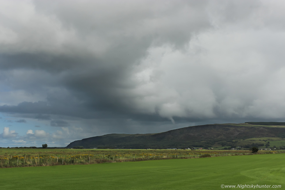
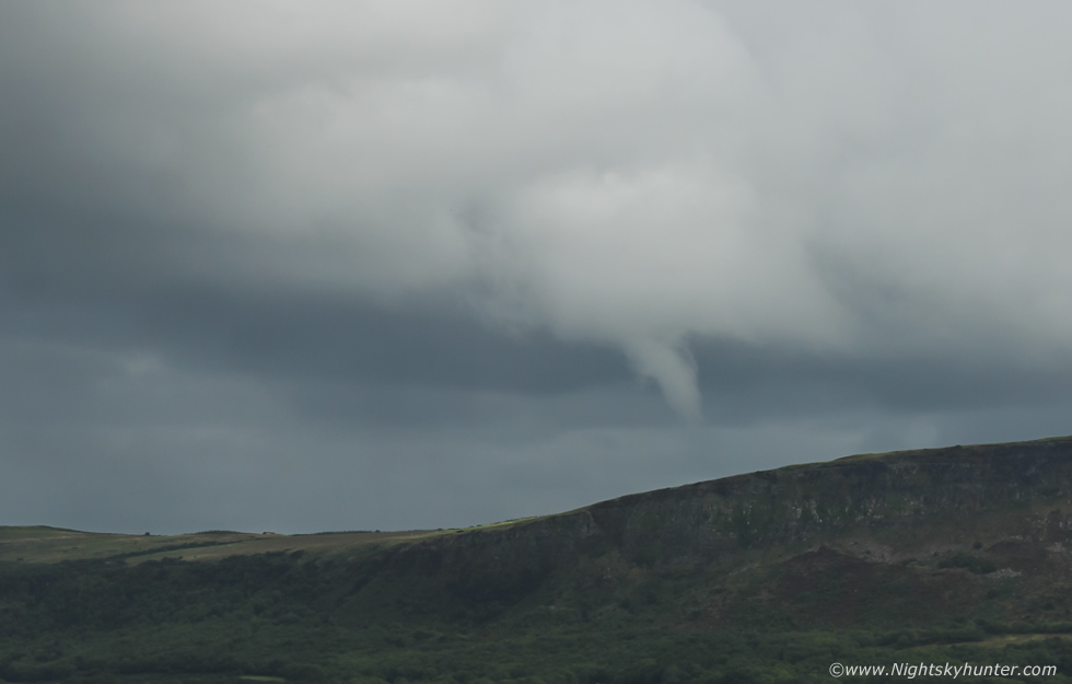
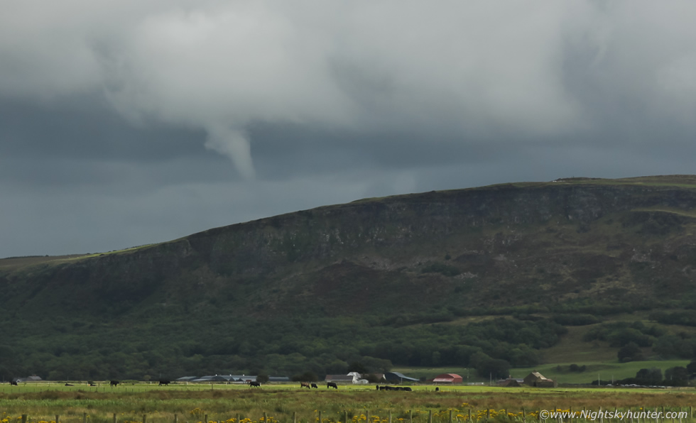
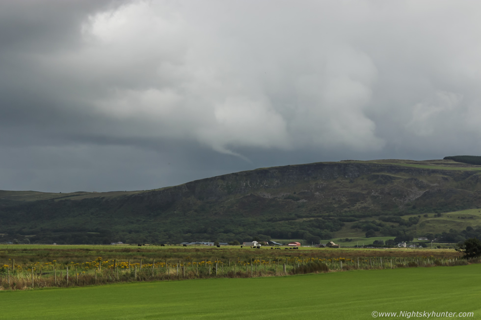
Then when I switched on my camera I realized with horror that all my settings were still for night shooting, I had to reset everything, all this messing about cost me valuable min's and the funnel was still spinning in the sky, from the time I had first spotted it on the road it must have been five min's already, it likely wouldn't last for much longer, I got my act together and crossed the road, leaned on a fence, and began shooting stills, this wide image captures the entire scene, I was facing E looking towards Binevenagh, the white clouds mark the rear (flanking area) of the cell which was moving away from me on the NWly flow which was taking up a fairly large area of sky, the dark cloud and rain to the upper left was not associated with the cell.
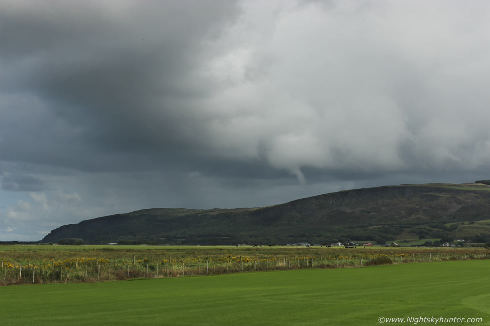 |
As I was shooting I took plenty of brief breaks to observe visually, the funnel was rotating in a very obvious fashion and a striking sight to anyone who looked in that direction. In the distance you can see light precip falling on the other side of the mountain, that's the downdraught from the cell which was moving in that direction, the funnel had formed on a classic rain free base at the rear and was well separated from the core and catching full sunshine.
 |
I saw a car pull up behind our car and a guy out with his camera and telephoto lens, he was shooting it too, however I wished I had my own telephoto with me, no doubt the funnel would fill the frame with such a set up, however in a way I was happy with what I had because I was capturing much of the entire structure over these lush fields with the majestic Binevenagh all in the same frame.
 |
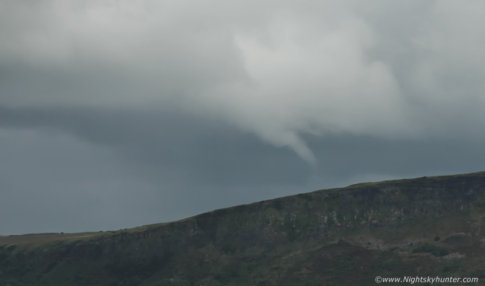
I could see fine tendrils of cloud wrapping around the tube as the funnel rotated, there was no doubt that this vortex was in the process of passing rite over the summit of Binevenagh itself. These are crops from 55mm captures.
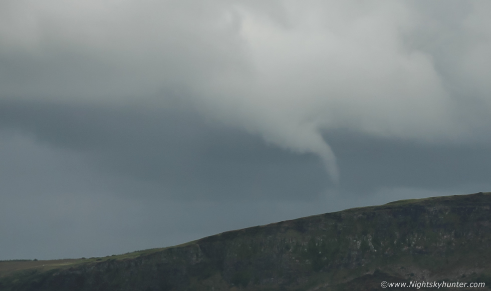 |
The funnel was constantly evolving while changing shape by the second, at this moment in time I assumed that many people were watching it and was fully expecting social media to be full of images of this transient visitor over a famous area of the coastline, anyone to the N side of the mountain would have had a terrific view of it, I would almost go so far to say that there were likely cars on the road to Gortmore who may passed near it and perhaps didn't see it rotating across their zenith.
 |
I saw two planes in the sky flying low around the mountain at this time including a helicopter, that black dot which looks like a fly to the left of the funnel is a chopper, here's the same view cropped in close.
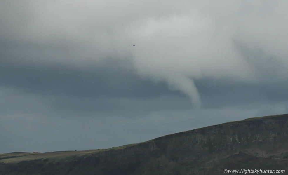 |
Chopper and funnel cloud, the pilot must have had an outstanding view from his airborne location, I wonder did he see it or was his view obstructed by the cockpit?
 |
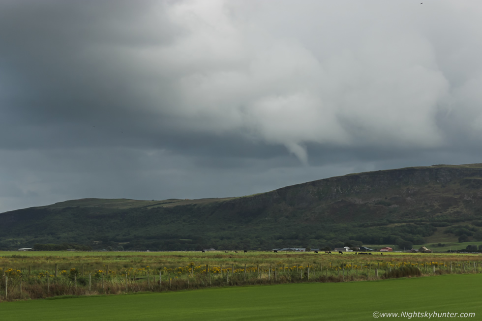
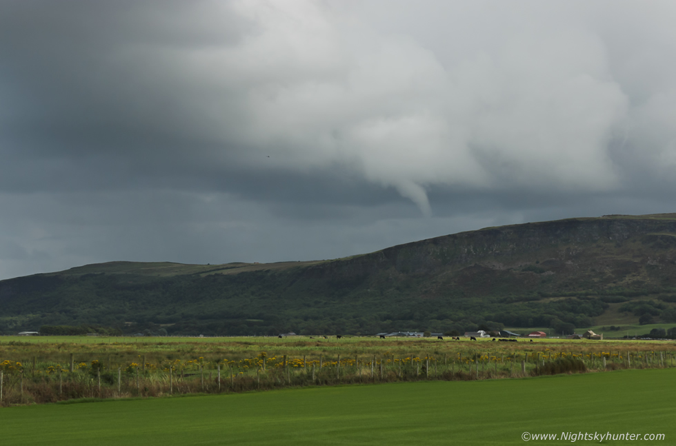
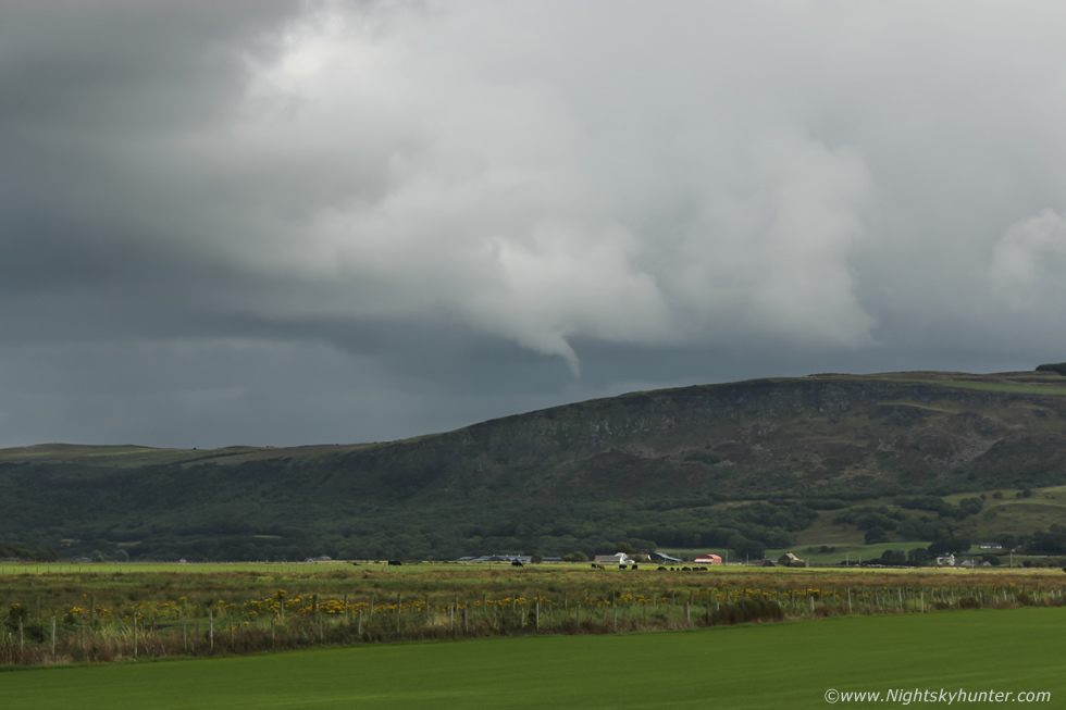
A very nice scene with the funnel over the sunlit fields with cows grazing below. This was looking along the axis of rotation, the funnel is foreshortened from this angle, if you were located 90 degrees to the left of it you would be seeing a long white tube bending into a snout.
 |
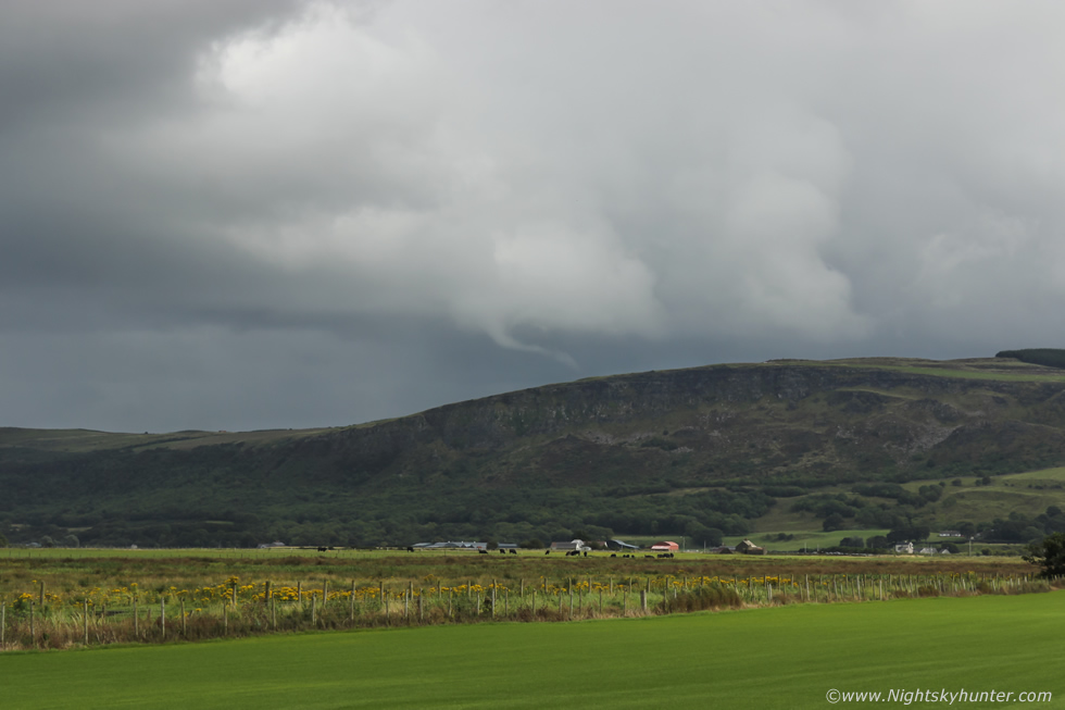
Funnel bending and reaching towards the summit and clearly well over the mountain, based on the images this was very close to the statue at Gortmore Viewing Point, I wonder did anyone see it, there were plenty of cars parked there.
 |
Another deep crop, I can only imagine how much rotation would have been evident if I had been filling the frame with the 100-400mm
 |
The funnel had then morphed into a long rope, the feature now appears smaller only because the cell is continuously moving away from me, had anyone been closer that rope would have been covering a large area of sky. Even small funnel clouds are sizable features when you consider their true length and cloud base altitude, at a guess this one was likely a couple of hundred metres long, but likey longer than that.
 |
Keep in mind that a funnel cloud is classified as a tornado when it makes contact with the ground or damage is reported below it. For those who don't know, the actual invisible vortex is much longer and wider than the visible condensation funnel you see with your eye, this is why for example in the states funnels even 1/3 of the way down from the base are often doing damage on the ground, you don't need to see the visible funnel going all the way from cloud base to ground level for a tornado to be happening. The cloud bases this day were high based, at least in comparison to sea level, the funnel was initially high above the surface, however the cell brought the area of interest over the top of Binevenagh itself which is far above sea level. Based on the length of the visible condensation funnel in relation to Binevenagh I belief there's a case to be made for brief contract with the surface, I suspect this could have been a weak tornado.
Following the sighting I have tried in vain to locate other witnesses on social media, I find it difficult to believe I was the only person to have seen this, after all, it was an obvious event at a popular tourist location on a Saturday afternoon, to me it was visible for 10 min's between 14.25 and 14.35 BST. I wonder did any of the pilots see it?, I would be very interested in any sightings from the Binevenagh/Gortmore areas, any information could help confirm if this touched down or not. Did anyone see rapidly rotating clouds in the sky?, did they experience a sudden strong gust of wind which was swirling?, was a whirlwind type vortex sighted on the mountain?, I hope that someone comes forward eventually, perhaps rain was blocking their view, who knows. I can tell you it was a beautiful sight with the naked eye, white and well formed, as my Mum said it actually looked alive, to experience something like this after a storm starved Summer on a day of weak potential completely took me by surprise, however witnessing it from this area of outstanding natural beauty which I have come to love in recent years felt like a very special moment.
How did it happen?
The synoptic situation for Saturday indicated a marginally unstable flow of maritime origin. Models showed between 50 and 100 j/kg of CAPE with LIs actually positive. In such situations the positive lifted index would prevent thunderstorm formation or at least it would be extremely unlikely. Forcing would be a combination of solar heating over land and warm SSTs (sea surface temperatures) which would supply sufficient moisture to aid with cell formation. CAPE was expected to leave the area by early to mid afternoon due to increasing subsidence which is why the local forecasts had went for dry weather from the afternoon onwards. The one chart I did see showed light showers inland and no showers at all over the coast, it was for this reason alone I decided to venture to the coast for drone filming.
This set up would produce a day of well scattered showers, convective in nature, however with limited cloud top height which would suppress thunderstorm development but which could still form low topped cells. There was no wind shear present for organization as the jet stream associated with a cold front had already passed through over 24 hours earlier. There was however convergence, the wind flow inland varied somewhat from a SWly to a Wly, there would also be a sea breeze interacting with the surface flow from the NW, convergence takes place went opposing wind fields meet, this becomes a focus point for convection and rotation. In my mind's eye the situation plays out like this - sometime after 13.00 an updraught is born over the ocean feeding on the warm SSTs, the sea breeze sends it towards the coastline where it crosses Donegal, it may have been encouraged by the terrain in that area, the Foyle helped maintain its supply of moist air then after 14.00 it made landfall where converging winds formed a vortex (rotating column of air). The cell would have experienced sudden orographic lift when it encountered Binevenagh forcing it aloft and aiding growth. Surface winds would have been dramatically tilted into the vertical thanks to the steep rising cliff face of the mountain, you can see this quite often when gliders surf the invisible thermals in that area. In this situation the cliff face would have enhanced the winds aloft which in turn would have fed straight into the cell's updraught stretching the already convergence-induced vortex and generating a funnel cloud. For a brief time this rising air shaped by Binevenagh itself may have substituted as a stronger updraught, when the cell crossed the summit the funnel weakened and vanished because this supply of ascending air was suddenly cut off, this is my theory on what happened.
Funnel spotting advice & lessons learned
What can be learned from this funnel cloud encounter and how can you uncrease your own chances of catching a funnel?
1) Always expect the unexpected, make sure you have all your important camera gear with you, even if a day is only slightly convective bring your camera and lenses just in case, for even if you don't get a funnel or tornado then at least you will have your camera gear close to hand in case of something else unexpected not related to the weather which may require various focal lengths.
2) Always select appropriate settings on your camera before going out into the field. Before a night shoot get everything set up in advance, bulb mode, ISO, aperture wide open, 2 sec timer, lens on manual focus, white balance, mirror locked up and cable release inserted. This way when you arrive on location you can take advantage of a sudden aurora which manifests upon your arrival, your camera is already prepped, all you have to do is focus, compose the image and take the exposure. The same applies to potential storm days, when you come back from a night shoot make sure you have selected your daytime shutter, ISO and WB settings so you can save valuable time if a convective event does happen in extremely short notice, it doesn't need to be a funnel, a sunset mammatus display or fleeting rainbow can be captured saving you valuable seconds, also make sure your batteries are charged beforehand too.
3) Keep your camera gear close to hand, whether your'e at home or in your car, you should know where your gear is stored and be able to access it rapidly.
4) Never ignore synoptic set-ups which seem unlikely to produce. We all get excited by the big forecasts with high CAPE however from experience these seldom produce, in fact, the lesser set-ups are the events which are most likely going to yield photogenic events (in this country). Pay close attention to days with low CAPE and high shear or low CAPE and good convergence, these have a habit of producing funnel and tornado events in Ireland. If you see convergence on the charts get yourself to that location.
5) Low cloud bases are great for mean storm clouds and any funnels which do form have less distance to reach the ground and a greater chance of becoming tornadoes, however low bases can be present in poor visibility or hidden by obstructions. High cloud bases are less photogenic however funnel clouds can be spotted from a much greater range, especially in clean maritime air masses, they are less likely to reach the ground but sometimes they do and in this case cell motion across higher terrain can turn the tables quickly.
6) Choose a location free from tall trees, mountains or houses, if your horizon is obstructed you are less likely to spot a funnel cloud. Get into the open countryside with a good horizon, on top of a hill or mountain (as long as it's not within the cloud base level) or over the ocean.
7) Pay attention to large bodies of water, especially large lakes and coastal areas, here increased moisture and temperature variations can aid with convection and funnel cloud formation, especially if local terrain places a role which encourages local convergence.
8) Shock factor, when you first spot a funnel or think you may be in the presence of a funnel forming your natural instinct is to freeze, you second guess yourself, is it?, isn't it?, you are wasting time, if you find yourself thinking this then take my advice and take action immediately, stop the internal voice in your head and grab your camera, select the lens you need, take an image to get the exposure correct, THEN watch to see if it develops, that way if something spectacular does happen you are ready, if it doesn't then no harm is done, consider it a training drill.
I live by these tips, I have been doing them for years yet still I messed up by not bringing my telephoto lens, I have it with me almost all the time, however on the one day I needed it the lens was at home, that's life for you and that's nature, she will surprise you when you least expect it so stay vigilant, observe the skies, be passionate and sooner or later you will be rewarded with something special.
Short video clip taken with the DSLR and 18-55mm kit lens. After the funnel had vanished I was buzzing for quite some time, we enjoyed a nice BBQ under pleasant evening sunshine and I did my drone filming too, I couldn't have asked for a better day than that, thanks for reading.
Martin McKenna